About Department
The department of Soil and Water Conservation Engineering is conducting teaching of B. Tech., M. Tech., Ph.D. programmes. Also taking active participation in carrying out need based research and extension activities in the University. At present only 4 faculty members are working in the department to carry on all the activities related to teaching, research and extension as well as conducting/guiding student research for M. Tech. and Ph. D. programme. The faculty in the department is involved in different extension activities of the University and also involved in carrying out other University level assignments. The department main thrust to develop the farmers oriented technology for rainwater harvesting and conservation of soil and water resources in changing climatic climate a future challenge to upcoming community.
Historical perspective of the department: The Department of Soil and Water Management was established at the time of inception of the faculty of Agricultural Engineering and Technology in 1984. Which was latter bifurcated into two separate department ciz, Department of Soil and water Conservation Engineering and Department of Irrigation and Drainage Engineering during 1992. The department has bright opportunity to developed farmer oriented technology for mitigating climatic change parameters for sustainable agricultural productivity.
Academic Programmes
- M Tech (Agricultural Engineering) in Soil and water Conservation Engineering with intake capacity 5
- Ph D (Agril Engg) in Soil and Water Conservation Engineering with intake capacity 2
- M Tech Courses
- Course Courses (Total Credits) : 21
- Minor Courses (Total credits) : 6
- Supporting Courses (Total Credits) : 6
- Research (Total credits) : 20
- Seminar (Total credits) : 1
- Total M Tech Credits : 57
| Sr. No | Course No. | Title of the courses Credits | Credits |
| A) | Major | (Core Courses) (min. 20 credits) | |
| 1 | SWCE 501 | Watershed Hydrology | 3 (2+1) |
| 2 | SWCE 502 | Design of Soil and Water Conservation Structures | 3 (2+1) |
| 3 | SWCE 503 | Open Channel Flow for Runoff Water | 3 (3+0) |
| 4 | SWCE 504 | Watershed Management and Modelling | 3 (2+1) |
| 5 | SWCE 505 | Project Planning for Land and Water Resources | 3 (3+0) |
| 6
|
SWCE 506 | GIS and Remote Sensing for Natural Resources Management | 3 (2+1)
|
| 7 | SWCE 507 | Land Development and Earth Moving Machinery | 2 (2+0) |
| 8 | SWCE 508 | Advances in Runoff Water Harvesting | 2 (1+1) |
| 9 | SWCE 509 | Fluvial Hydraulics | 3 (2+1) |
| 10 | SWCE 510 | Statistical Hydrology | 3 (3+0) |
| 11 | SWCE 511 | Dams and Reservoir Operations | 3 (2+1) |
| 12 | SWCE 592 | Special Problem | 1 (0+1) |
| 13 | SWCE 595 | Industry/ Institute Training (3 week) | NC |
| B) | Minor | (Optional Courses) (min. 9 credits) | |
| 1 | MATH 501 | Higher Engineering Mathematics | 3 (2+1) |
| 2 | MATH 502 | Methods of Numerical Analysis | 2 (1+1) |
| 3 | MATH 503 | Advanced Calculus for Engineers | 2 (2+0) |
| 4 | STAT 511 | Statistical Methods for Applied Science | 3 (2+1) |
| 5 | STAT 512 | Experimental Design | 3 (2+1) |
| 6 | IDE 504 | Ground Water Engineering | 3 (2+1) |
| 7 | IDE 505 | Crop Environmental Engineering | 2 (2+0) |
| 8 | IDE 507 | Flow through Porous Media | 2 (2+0) |
| 9 | IDE 511 | Introductory Hydro Informatics | 3 (2+1) |
| C) | Supporting | (min. 5 credits) | |
| 1 | BSCT 501 | Computer Graphics | 3 (2+1) |
| 2 | BSCT 502 | Computer Languages for Engineering Applications | 3 (1+2) |
| 3 | MATH 504 | Neural Network and its Applications | 3 (2+1) |
| 4 | AE 502 | Similitude in Engineering | 3 (2+1) |
| 5 | AE 503 | Applied Instrumentation | 3 (2+1) |
| 6 | FMPE 521 | Computer Aided System Design | 2 (0+2) |
| D) | Seminar | (01 credit) | |
| 1 | SWCE 591 | Seminar | 1(0+1) |
| E) | Non Credit compulsory courses | ||
| 1 | PGS 501 | Library and Information Services | 1 (0+1) |
| 2 | PGS 502 | Technical Writing and Communications Skills | 1 (0+1) |
| 3 | PGS 503 (e-Course) | Intellectual Property and its Management in Agriculture | 1 (1+0)
|
| 4 | PGS 504 | Basic Concepts in Laboratory Techniques | 1 (0+1) |
| 5 | PGS 505 (e-Course) | Agricultural Research, Research Ethics and Rural Development Programmes | 1 (1+0)
|
| 6 | PGS 506 (e-Course) | Disaster Management | 1 (1+0) |
| F) | M Tech Research (minimum credits 20) | 20 (0+20) | |
4) Ph D Courses
- Course Courses (Total Credits) : 15
- Minor Courses (Total credits) : 08
- Supporting Courses (Total Credits) : 05
- Research (Total credits) : 45
- Seminar (Total credits) :02
- Total Ph D Credits : 75
| Sr. No | Course No. | Title of the courses Credits | Credits |
| A) | Major | (Core Courses) (15 credits) | |
| 1 | SWCE 601 | Advanced Hydrology | 3+0=3 |
| 2 | SWCE 602 | Modeling Soil Erosion Processes | 2+1=3 |
| 3 | SWCE 603 | Soil and Water Systems’ Simulation and Modeling | 2+1=3 |
| 4 | SWCE 604 | Hydrological Analysis of Watershed | 2+1=3 |
| 5 | SWCE 605 | Hydrological Models | 2+1=3 |
| 6
|
SWCE 606 | Advanced Hydro informatics | 2+1=3 |
| 7 | SWCE 607 | Risk Management in Soil and Water Conservation | 2+1=3 |
| 8 | SWCE 693 | Special Problem | 0+1=1 |
| 9 | SWCE 694 | Case Studies | 0+1=1 |
| B) | Minor | (Optional Courses) (8 credits) | |
| 1 | AE 601 | Environmental Impact Assessment | 1+2=3 |
| 2 | AE 602 | Climate Change Impact Adaptation and Mitigation | 2+1=3 |
| 3 | AE 603 | Research Techniques | 2+1=3 |
| 4 | AE 604 | Bench Marking and Performance Analysis | 3+0=3 |
| 5 | IDE 605 | Pipe Network Analysis | 2+1=3 |
| 6 | IDE 606 | 2+1=3 | |
| C) | Supporting | (5 credits) | |
| 1 | CSE 601 | Object Oriented Programming | 2+1=3 |
| 2 | MATH 601 | Mathematical Modelling and Mat lab Applications | 1+2=3 |
| 3 | STAT 601 | Operations Research | 2+1=3 |
| 4 | STAT 602 | Probabilistic Approach in Design | 2+0=2 |
| 5 | STAT 603 | Geospatial Analysis | 1+1=2 |
| D) | Seminar | (2 credits) | |
| 1 | SWCE 691 | Doctoral Seminar I | 0+1=1 |
| 2 | SWCE 692 | Doctoral Seminar II | 0+1=1 |
| E) | Non Credit compulsory courses | ||
| 1 | PGS 501 | Library and Information Services | 1 (0+1) |
| 2 | PGS 502 | Technical Writing and Communications Skills | 1 (0+1) |
| 3 | PGS 503 (e-Course) | Intellectual Property and its Management in Agriculture | 1 (1+0) |
| 4 | PGS 504 | Basic Concepts in Laboratory Techniques | 1 (0+1) |
| 5 | PGS 505 (e-Course) | Agricultural Research, Research Ethics and Rural Development Programmes | 1 (1+0) |
| 6 | PGS 506 (e-Course) | Disaster Management | 1 (1+0) |
| F) | Ph D Research Project (Mini Credits) : 45 | 45 | |
Infrastructure Facilities
- Developed different onfarm soil conservation measures, Water harvesting structures, Gully control structures designed and constructed at University farm.
- Well-equipped labs for teaching to the UG and PG students of the department.
- Different soil and water conservation measures, structural models developed and installed at Agricultural Technology Information Centre, Dr. P. D. K, V, Akola.
List of Laboratories: 1) Surveying and Levelling laboratory
2) Soil Mechanics and Hydrology lab
Mandate
In changing climate scenario, there is a need to change our research priorities especially under rainfed agriculture for judicious use of available rainfall and amelioration of stresses due to biotic and abiotic factors. Conservation agriculture has potential for managing the declining soil productivity besides, managing the climate change. Studies have found that the threat to water security is very high over central India, along the mountain ranges of the Western Ghats, and in India’s northeastern states.
- To undertake, formulate and implementation of site-specific schemes to conserve and manage soil and water resources in the region.
- To take up appropriate water conservation measures in and outside forest area, impounding of water wherever sites permit to increase ground water recharge and prevent floods.
- To coordinate with the institutions and departments working on water conservation in the state.
- To provide technical guidance for preparation of schemes on scientific basis for other line departments and implement catchment area treatment projects wherever required.
- Conduct hydrological evaluation of watersheds under different land use and management practices with the objective of establishing rainfall-runoff relationships.
- To create awareness about soil and water conservation by adopting suitable communication strategy and extension measures.
- Teaching to U G (B Tech Agri Engg), M Tech (Agril Engg) and Ph D (Agril Engg), Research and Extension
Research Activities
Thrust area:
The future thrust areas on which the department is focusing are:
- Use of remote sensing and GIS technology for conservation, monitoring and improvement of natural resources.
- Optimization of on farm water harvesting strategies and development of ground water resources.
- Studies on the hydrological behavior of the watersheds for developing and monitoring natural resources.
- Drought characterization and monitoring for effective assessment of ground level facts, so as to warn the farmers or suggest suitable remedial measures.
- Development of contingent cropping strategy for major rainfed crops of the region with special emphasis on soil and water conservation to cope up with delay in monsoon and midseason droughts i.e., climate change situation.
- Location specific soil and water conservation strategies for minimizing adverse impact of rainfall variation.
- Water security to various sectors of the community in addition to imbibing water literacy among the citizens of our nation via implementation of various rainwater and sustainable water management systems.
- Location specific bio-engineering measures for different degraded lands.
- Effective rain water management in catchment areas though interbasin water utilization.
- Water conservation literacy and Awareness.
The future thrust areas on which the department is focusing are:
Topic of Educational research
a) M Tech (Agril Engg)
| Sr. No | Name of student | Title of Thesis | Name of the Guide | Year of passing |
| 1 | P.L. Narnaware | Planning of an agricultural micro watershed with special reference to soil and water conservation-A case study. | Prof. V. B. Dalvi | 1987 |
| 2 | B.W. Bhuibhar | Rainfall erosion index for Vidarbha region. | Prof. V. B. Dalvi | 1987 |
| 3 | N.R. Kolhe | Dry spell probability analysis and its application to crop developmental stages. | Prof. V.B. Dalvi | 1988 |
| 4 | S.M. Taley | Evaluation of erosion potential from rainfall data for Vidarbha | Prof. V. B. Dalvi | 1988 |
| 5 | D.G. Dhatrak | Development of station monographs in Vidarbha region. | Prof. V. B. Dalvi | 1989 |
| 6 | G.R. Atal | Planning of an agricultural micro watershed at Akola-A case study. | Prof. S. B. Jajoo | 1989 |
| 7 | S.B. Surose | Economical design of graded bund. | Prof. R. L. Gawande | 1990 |
| 8 | A.J. Agrawal | Studies on different system for rain water management. | Prof. V.B. Dalvi | 1991 |
| 9 | B.T. Taksale | Drought analysis for Marathwada region. | Prof. V. B. Dalvi | 1992 |
| 10 | P.R. Shende | Evaluation of soil and water conservation structures in selected watersheds of district Akola. | Dr. M. N. Pawade | 1992 |
| 11 | D.N. Jallawar | Evaluation of cement nala plug.
|
Prof. G. U. Satpute | 1993 |
| 12 | R.B. Ugale | Studies on different soil and water conservation treatments. | Prof. G. U. Satpute | 1995 |
| 13 | S.V. Uplanchiwar | Effect of watershed management on ground water potential. | Prof. R. L. Gawande | 1995 |
| 14 | A.M. Dani | Water harvesting in assured rainfall zone of Vidarbha region. | Prof. V. B. Dalvi | 1995 |
| 15 | N.N. Kolte | Studies on hydrologic soil characteristics of watershed. | Prof. G. U. Satpute | 1996 |
| 16 | A.R. Mhaske | Development of growth models for prediction of precipitation and crop planning. | Prof. V.B. Dalvi | 1996 |
| 17 | R.S. Jadhav | Studies on curve number for runoff estimation. | Prof. G. U. Satpute | 1998 |
| 18 | K.D. Gharde | Modeling of one-dimensional water flow in unsaturated zone of the watershed. | Prof. M. B. Nagdeve | 1999 |
| 19 | Ku. J.P. Patil | Probability models for prediction of annual maximum one day rainfall for Vidarbha region. | Prof. V. B. Dalvi | 1999 |
| 20 | P.W. Jadhav | Assessment of groundwater recharge in a watershed-A modeling approach. | Prof. G. U. Satpute | 1999 |
| 21 | P.G. Kolhe | Determination of curve numbers for some conservation practices. | Prof. G. U. Satpute | 2001 |
| 22 | S.G. Solanki | Estimation of cropping management factor (C) and supporting conservation practice factor (P) at Akola. | Prof. S. B. Jajoo | 2001 |
| 23 | Ku. S.R. Mundle | Study on runoff factor and cropping management factor of soil loss equation at Akola. | Prof. S. B. Jajoo | 2002 |
| 24 | K.T. Nikumbh | Development of soil erosion map of Vidarbha region. | Prof. V. B. Dalvi | 2002 |
| 25 | S.N. Manwar | Remote sensing and geographic information system for watershed development. | Prof. S.B. Jajoo | 2004 |
| 26 | S.P. Patil | Study on different sealing materials for reducing seepage in farm ponds. | Dr. V.B. Dalvi | 2004 |
| 27 | Ku. N.D. Bhagat | Evaporation control using floating materials in small farm ponds. | Dr. V. B. Dalvi | 2006 |
| 28 | S.E. Khetmalas | Comparative study of drought indices at Akola. | Dr. G. U. Satpute | 2006 |
| 29 | P.A. Kamble | Hydrological water balance modeling for assessing productivity. | Dr. M. B. Nagdeve | 2006 |
| 30 | A.R. Surse | Drought characterization in western Vidarbha. | Dr. G.U. Satpute | 2007 |
| 31 | Ku.K.V. Mahadadalkar | Optimal resources utilization for sustainable agriculture in Belura watershed. | Prof. S.B. Jajoo | 2007 |
| 32 | Ku. N.B. Dabare | Comparative study of meteorological drought indices in eastern Vidarbha. | Dr. G. U. Satpute | 2007 |
| 33 | J.A. Khade | Rainfall analysis for crop planning in Akola district. | Dr. G. U. Satpute | 2008 |
| 34 | Ku. P. G. Kamble | Optimal resources allocation crop plan for Buldhana district of Vidarbha Region. | Prof. S. B. Jajoo | 2009 |
| 35 | Ku. P. R.Bhamre | Development of Rainfall Intensity-Duration-Frequency Relationship and Station Nomograph for Amravati Division | Dr. G. U. Satpute | 2010 |
| 36 | Y. R. Mahalle | Assessment of storage losses from dug out type farm pond in saline tract | Dr. G. U. Satpute | 2011 |
| 37 | Ku. A. S. Kadam | Event based rainfall runoff simulation using HEC-HMS model | Dr. G. U. Satpute | 2011 |
| 38 | A. S. Nagare | Impact of dug out type farm ponds at Ghusar village in Purna valley | Prof. R. C. Bhuyar | 2011 |
| 39 | P. T. Shinde | Development of rainfall intensity-duration-frequency constants, curves and nomographs for selective stations of Vidarbha region | Prof. S.B. Jajoo | 2011 |
| 40 | Ku. A. P. Tiwane | Resource Conservation in Cotton Under Rainfed Condition | Dr. M. B. Nagdeve | 2011 |
| 41 | P. S. Powar | Effect of embankment height on evaporation loss from dug out type farm pond | Dr. G. U. Satpute | 2012 |
| 42 | Ku. D. D. Kothawale | Development of rainfall intensity-duration-frequency constants and nomographs for selected stations of Nagpur division. | Prof. S.B. Jajoo | 2012 |
| 43 | Ku. S. S. Patil | Evaluation of in-situ soil and water conservation measures for cotton (Gossypium arborium) crop | Dr. S. M. Taley | 2012 |
| 44 | N. S. Tariku | Modeling one dimensional water flow in Vadose Zone using ‘HYDRUS’ | Dr. M. B. Nagdeve | 2012 |
| 45 | Ku. K. Y. Dhoke | Studies on resource conservation in sorghum using energy estimates under rainfed condition | Prof. R. S. Patode | 2013 |
| 46 | Ku. V. P. Barwal | Rainfall analysis for crop planning in Chandrapur district | Dr. G. U. Satpute | 2013 |
| 47 | A. U. Survase | Study of dug out type farm ponds in Ghusar village of Akola taluka | Dr. G. U. Satpute | 2013 |
| 48 | M. P. Sathe | Impact of land configurations on runoff, soil loss and productivity of cotton under rainfed conditions | Dr. S. M. Taley | 2013 |
| 49 | Ku. D. B. Bhamare | Effect of conservation practices on soil moisture, production and water use efficiency in hybrid sorghum (Sorghum bicolor) | Dr. S. M. Taley | 2013 |
| 50 | R. T. Chavhan | Effect of treated sewage water by phytorid wet land technology on soil and leafy vegetables | Dr. S. M. Taley | 2013 |
| 51 | Ku. A. D. Pundlik | Runoff Prediction with Artificial Neural Network | Dr. S. M. Taley | 2014 |
| 52 | Ku. S. S. More | Effect of Moisture Conservation Measures on Runoff, Soil Loss and Curve Numbers | Dr. S. M. Taley | 2014 |
| 53 | Ku. Chippy Jasmine Francis | Effect of surface and subsurface tillage on in- situ soil and water conservation in hybrid sorghum(Sorghum bicolar) | Dr. S. M. Taley | 2014 |
| 54 | M. G. Kale | Application of HEC- GEOHMS for watershed management | Dr. S. M. Taley | 2014 |
| 55 | Ku. C. V. Thakare | Comparative study of meteorological drought indices in Amravati district | Dr. G. U. Satpute | 2014 |
| 56 | V. P. Pandagale | Study on indirect estimation of available water capacity of soils on watershed basis | Dr. G. U. Satpute | 2014 |
| 57 | S. B. Deore | Study on utility of harvested rainwater in farm ponds of saline area | Dr. G. U. Satpute | 2015 |
| 58 | Ku. P. D. Naitam | Impact Assessment of Seasonal Rainfall on Agriculture Vegetation and Water Bodies in Akola and Washim District using RS and GIS Technology | Dr. G. U. Satpute | 2015 |
| 59 | Ku. Karishma Chitte | Impact of Tillage Practices on Soil Water Conservation and Energy Efficiency in Cotton Under Rainfed Condition | Dr. S. M. Taley | 2015 |
| 60 | Ms. A. S. Yeole | Efficient moisture conservation practices for maximizing sorghum productivity, water and energy use efficiency in rainfed agriculture | Dr. S. M. Taley | 2015 |
| 61 | Ms. R. M. Wankhade | Hydrological response of continuous contour trenches under dryland condition | Prof. R. S. Patode | 2015 |
| 62 | Shri D B Patil | Impact Assessment of Watershed management Through Remote Sensing and Geographical Information system | Dr. S M Taley | 2016 |
| 63 | Miss Sonali Swagatika | Water analysing of small watershed | Dr. S M Taley | 2016 |
| 64 | Shri Shivkuma Anna | Study of dryspell in Akola district using geomatics | Dr. G U Satpute | 2016 |
| 65 | Shri S S Mankar | Study of seasonal Rainfall variation on rainfed agriculture in Yawatmal district using Geoinformatics | Dr. G U Satpute | 2016 |
| 66 | Shri R M Beldar | Rainfall analysis of Akola, Yawatmal and Sindhewai station in Vidharbha using Statistical Parameter and non parametric test | Dr. S M Taley | 2017 |
| 67 | R S Rajput | Assementy of climatic water balance and length og growing period | Dr. S M Taley | 2017 |
| 68 | Shri D Mahender Reddey | Hydrological investigation of Watershed for water Resources management | Dr. R S Patode | 2017 |
| 69 | Miss P S Kute | Study of seasonal rainfall Impact on Rainfed Agriculture and major water Bodies in Buldhana District using RS and GIS | Dr. G U Satpute | 2017 |
| 70 | Shri Anil Ganesh Chavan | Study of dry spells ion Washim District using Geoinformatics | Dr. G U Satpute | 2017 |
b) Ph D Agril Engg ) Thesis
| Sr. No | Name of student | Title of Thesis | Name of the Guide | Year of passing |
| 1 | Shri. G L Chunale | Optimization of rain water harvesting storage structures based on hydrological modelling | Dr. G U Satpute | 2012 |
| 2 | Shri A R Mhaske | Converting Sewage into Water Resources by using Phytorid wetland Engineering technology for Agriculture. | Dr. S M Taley | 2014 |
| 3 | Shri. V N Barai | Studies on Spalsh erosion under Simulated rainfall | Dr. G U Satpute | 2015 |
| 4 | Miss M S Supe | Optimization of Water foot prints (Green and Blue) for River Basin | Dr. S M Taley | 2015 |
| 5 | Shri S N Bansode | Study on Model to Describe Soil and Water Retention function in Shirula Nemane Watershed | Dr. G U Satpute | 2016 |
| 6 | Shri S K Upadhye | Optimization of water conservation strategies using SWAT | Dr. S M Taley | 2018 |
Adhoc research schemes /projects undertaken
| Sr. No. | Title of Research Project | Sponsored by | Amount Rs in lakhs |
Name of P.I and Co. P.I |
Period Years From – To |
|---|---|---|---|---|---|
| 1 | Utilization of improved kharif water management technology under Maharashtra Irrigation technology and management project (MIT&M.USAID) | USAID | 1.92 | Dr. M.N.Pawade Dr. S.B. Wadatkar |
1985-1988 |
| 2 | Agricultural water management studies under Maharashtra Irrigation technology and management project (MIT&M.USAID) | USAID | 3.60 | Dr. M.N.Pawade Dr. S.B. Wadatkar |
1985-1988 |
| 3 | USAID Assisted water management project at Borjawala Dist. Buldana | USAID | 1.50 | Dr. M.N.Pawade Dr. V.B. Dalvi Dr. T.H. Rathod |
1990-1991 |
| 4 | Study of drip irrigation system on some fruit crops and vegetables | ICAR, New Delhi | 3.58 | Dr. V.B. Dalvi | 1991-1995 |
| 5 | Scaling up of water productivity in agriculture for livelihood through teaching cum demonstration, Training of Trainers and Farmers | ICAR, New Delhi | 124 | Er.S.B Jajoo Dr. S.B. Wadatkar |
2007-2012 |
Research Achievements
The research work in this deptt. is concentrated on theme areas like rain water management systems, in situ rain water conservation, analysis of climatologically data, runoff and soil loss estimations, controlling losses in farm pond, soil moisture modeling drought characterization etc.
The salient contributions of the department are as below
- From the analysis of climatologically data of the region; the information is generated on,
- a) Onset of effective monsoon and critical dry spell in all districts of Vidarbha
b) Dry spell nomograms for all important crops of this regions
c) Intensity frequency stations nomograms for all districts of Vidarbha.
d) Developed iso-erodent map of Vidarbha to estimate EI at any location.
e) Developed soil erosion map of Vidarbha to priorities programme. - Rainfall Runoff relationship in the form of SCS curve numbers are established.
- Soil erodibility values K for shallow and medium deep soils are determined.
- Drought characterization in Amravati & Nagpur division.
- Rain water harvesting systems for in situ moisture conservation in rainfed farming.
- Cropping factor of various crops in Vidharba region.
- Roof top rain water harvesting systems.
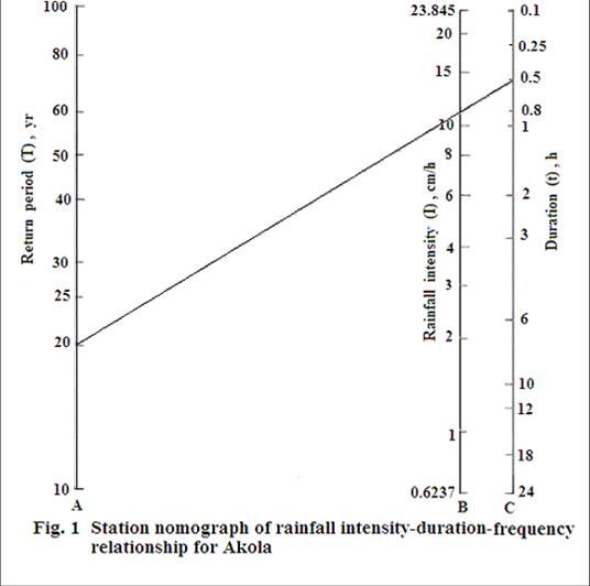
- The rainfall-intensity duration frequency relationship developed for Akola.
- Published a book on drip irrigation with financial support by Govt. of Maharashtra.
- Published a book on drought in Vidarbha by Dr P.D.K.V , Akola.
- Published a booklet on intensity duration frequency equations for different regions in Maharashtra state
- Published Sixty research article by different staff members of this discipline.
- Number of students of M.Tech. in Soil Water Conservation Engg. Discipline completed- 50
- Number of students of Ph. D. in Soil Water Conservation Engg. Discipline completed- 01
Extension Activities and Achievements
- Training programmes organised for farmers / women’s / rural youth etc with best 4 HD quality photographs : provide list of last five years
- Manual /Bulletins published : Provide list of publication of last five years
- Text Books and Mannual : provide list of publication of last five years in English
Research Recommendations (Approved in AGRESCO)
1. For runoff estimation from the land use of field crop with practices of along the slope cultivation and contour cultivation along vegetative keylines in the watershed having hydrologic soil group ‘B’ (with initial abstraction, a as 0.3 S), the following curve numbers are recommended:
|
Sr. No.
|
Practices
|
Storm group*
|
Antecedent Moisture Conditions
|
||
|---|---|---|---|---|---|
|
I
|
II
|
III
|
|||
|
1
|
Along the slope cultivation
|
Small
medium Large |
84
81 66 |
89
82 81 |
91
88 86 |
|
2
|
Contour cultivation along leucaena key lines
|
Small
Medium Large |
81
80 63 |
86
81 74 |
87
86 81 |
* Small storms (2.5 to 30 mm), Medium storms (30 to 60 mm) and Large storms
(above 60 mm).
2. Aridity index is recommended for identification of agricultural droughts.
3. Agricultural drought characterization study in 32 talukas of six drought affected districts of Vidarbha indicate the occurrence of high intensity agricultural drought once in four years in the talukas mentioned below. It is suggested that the development agency should plan and execute for water harvesting during normal and drought years to mitigate the impact of agricultural drought.
|
District
|
Talukas
|
|---|---|
| Buldhana | Khamgaon, Shegaon, Malkapur, Buldhana, Jalgaon- Jamod. |
| Akola | Akot, Telhara, Akola |
| Washim | Mangrulpir, Washim |
| Amravati | Anjangaon, Daryapur, Achalpur, Amravati, Morshi, Warud, Chandur-Bazar, Chandur-Railway |
| Yeotmal | Digras, Yeotmal, Wani, Umarkhed |
| Wardha | Wardha, Arvi, Hinganghat |
4. The rainfall intensity-duration-frequency (I-D-F) relationship and nomograph developed for Akola station is recommended for determination of design rainfall intensity for any duration up to 24 hour and a return period from 10 to 100 years to design flood control, rainwater harvesting and runoff disposal structures.
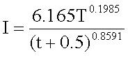
Where,
I = Rainfall intensity, cm\h
T= Return period, years
t = Time of concentration, hour
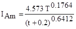
- The rainfall intensity-duration-frequency (I-D-F) relationship developed for Amravati station is recommended for determination of design rainfall intensity for any duration up to 24 hour and a return period from 10 to 100 years to design flood control, rainwater harvesting and runoff disposal structures.
- The rainfall intensity – duration – frequency (I-D-F) relationship developed for Wardha, Yeotmal, Bhandara and Buldhana station is recommended for determination of design rainfall intensity for any duration up to 24 hour and a return period from 10 to 100 years to design flood control, rainwater harvesting and runoff disposal structures.
For Wardha, 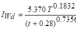 ; For Yeotmal,
For Bhandara,  ; For Buldhana,
- The developed maps for onset of effective monsoon, withdrawal of monsoon and occurrence of critical dry spell dates at taluka level in Amravati division is recommended for crop planning in the division.
- The embankment height of 2 to 2.5 m from land surface is recommended for dug out type farm ponds for reducing evaporation losses from it.
- The rainfall intensity – duration – frequency (I-D-F) relationship developed for Nagpur, Chandrapur, Gadchiroli and Gondia station is recommended for determination of design rainfall intensity for any duration up to 24 hour and a return period from 10 to 100 years to design flood control, rainwater harvesting and runoff disposal structures.
For Nagpur, 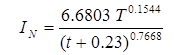 ; For Chandrapur,
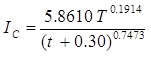
For Gadchiroli, 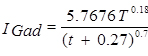 ; For Gondia,
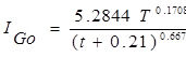
Publications

Contact Information
Dr. S.M. Taley
Head,
Department of Soil and Water Conservation Engg,
Dr. Panjabrao Deshmukh Krishi Vidyapeeth,
Krishi Nagar, Akola – 444 104 (M.S.)
Phone & Fax No. (0724) 2259404
E-mail: hdswce@pdkv.ac.in